Thursday, January 21, 2010

Boundaries of the Great Plains


The Boundaries of the Great Plains?

Walter Prescott Webb, the famous Western historian, in his seminal 1931 work The Great Plains argued that “the Great Plains environment … constitutes a geographic unity whose influences have been so powerful as to put a characteristic mark upon everything that survives within its borders” (8). Webb wrote that the Great Plains area “comprised a much greater area than is usually designated,- an area which may best be defined in terms of topography, vegetation, and rainfall” (3).

For Webb, “a plains environment, such as that found in the western United States, presents three distinguishing characteristics: 1. It exhibits a comparatively level surface of great extent. 2. It is a treeless land, an unforested area. 3. It is a region where rainfall is insufficient for the ordinary intensive agriculture common to lands of a humid climate. The climate is sub-humid” (3). Webb’s Great Plains, are much larger than many people consider even to this day. For example, Webb includes much of Iowa, Wisconsin and parts of Illinois in his definition of the “Great Plains environment” (1).

Ian Frazier, a journalist, wrote in his book Great Plains that the boundaries of the Great Plains were:
“The Great Plains are about 2,500 miles long, and about 600 miles across at their widest point. The area they cover roughly parallels the Rocky Mountains, which make their western boundary. Although they extend fom the Southwestern United States well into Canade, no single state or province lies entirely within them. North to south, the states of the Great Plains area: Montana, Wyoming, Colorado, New Mexico, Texas, North Dakota, South Dakota, Nebraska, Kansas, Oklahoma. . . In Canada, they include southern Alberta, Saskatchewan, and Manitoba. They are five hundred thousand miles inland from the Pacific Ocean, and over a thousand miles inland from the Atlantic. The Texas Plains are about five hundred miles from the Gulf of Mexico.” (6)

Frazier, like many scholars of the Great Plains, admitted as well that of “all the Great Plains boundaries, the eastern one is the hardest to fix” because the “same amount of rain never falls town years in a row” (7).

Richard Manning, a range management specialist and journalist, writes in his work Grassland that the idea of the Great Plains is best defined in the context of grassland ecology. Manning writes that “the creation of the American Great Plains as grassland was a function of the creation of the Rock Mountain chain. Before, the region had been a vast sea, then a vast flat forest. The puny teeth of the residents said so. The Rockies, however, rose and raised their rain shadow, which produced the aridity that killed the trees and created the grassland (39).” Manning’s boundary of the Great Plains is much more expansive than most others. Manning writes that the Great Plains roughly exist in the “sweep of plain between the Mississippi and the Rocky Mountains and the smaller grassland domains west of the Rockies” (1). Manning’s map of America’s grasslands (e.g. including most of Iowa with the exception of the Driftless region) is much more extensive than others because while he stresses that a necessary component of the Plains is aridity, for him aridity includes regions that receive “between ten and thirty inches of rainfall a year . . . anything drier is a desert; anything wetter, a forest” (2). Manning writes that “aridity is first the defining and implacable factor of grass” because “arid lands will not support trees in sufficient numbers to become a forest” and “dry land burns frequently and fire kills trees but not grass” (2). In short, while Manning does use the term the Great Plains in his work, I think, he finds it a flawed conception unless it is used to refer to all of North America’s grasslands. What many people would call the Great Plains, I think Manning would prefer having referred to as “the High Plains” or “short-grass steppe” (3).

I earned my MA from the University of Nebraska in Great Plains Studies. I have included the “official” map of the Great Plains that the Great Plains Center at UNL uses above. I copied this map from their website at http://www.unl.edu/plains/about/map.shtml. Personally, I have always thought that the map used by UNL was too culturally and U.S. history based and not reflective enough of environmental realities. For these reasons, I would favor the more expansive definitions of the Great Plains used by writers like Webb and Manning.

Work Cited
Frazier, Ian. Great Plains. New York: Picador, 1989.
Manning, Richard. Grassland: the History, Biology, Politics, and Promise of the American Prairie. New York: Penguin, 1997.
Webb, Walter Prescott. The Great Plains. Lincoln: University of Nebraska Press, 1981.
Tuesday, June 30, 2009

Next Semester

Congrats on the end of this semester folks. I hope you all (relatively) enjoyed the course. :)

Next fall I will be teaching:

History of Homesteading
and
History of the Great Plains and Rocky Mountains.

You are all more than welcome to take one or both of these courses. The reading lists will be completely different from what we read this semester.

Take care.
Have a good summer!

Dennis Kuhnel

Someone was being bad at work today

Wednesday, May 6, 2009

Dances with Wolves Movie Review

Dances with Wolves, a film made in the year 1990, revolves around John Dunbar, a United States soldier who decides to restore and old fort in the Great Plains.  When doing this restoration, Dunbar realizes that no white men seem to be coming, so he decides to explore and finds an Indian reservation of Sioux Indians.  While they are frightened of him at first, they later start to bond.  The Indians accept John Dunbar into their clan and call him Dances with Wolves.  After learning the Sioux language and their way of life, Dances with Wolves falls in love with one of their white members, Stands with a Fist.  The two get married, but shortly after, an army of white men comes to attack the Indians, and they capture Dances with Wolves.  However, a group of valiant Sioux Indians comes to save Dances with Wolves, and they take him back to their new winter village.  Dances with Wolves, however, is worried that the white men will come after him, and he does not want to put the Sioux in danger.  Therefore, Dances with Wolves and Stands with a Fist escape to new land, and leave the Indians behind in order to keep them safe the American soldiers.

When watching this movie, I noticed that the way of Indian and Great Plains life depicted in the movie was extremely similar to what we have learned this semester in class from our readings.  In The Comanche Empire, by Pekka Hamalainen, Comanche Indians took Mexican women and children hostage and then adapted them to the Indian way of life.  These Mexicans would marry into the tribe and usually become so happy that they did not want to return to their families in Mexico.  Similarly, Stands with a Fist was abducted from her white, English-speaking family at a young age.  Years later, she married a man in the Sioux tribe.  She became so accustomed to the Sioux way of life that when she first saw John Dunbar, she was frightened of the strange white man.  She felt that she was part of the Sioux tribe and did not want to leave. 

Another thing that I learn from my readings this semester was that trade and gifts were imperative to Indian lifestyles.  Trading forts such as Taos and Bent’s Fort provided Indians with food, horses, slaves, and more.  In the movie, Dances with Wolves and another Sioux Indian traded an American hat for an Indian garment.  Also, Dances with Wolves was offered a buffalo hide to show that the Sioux came in peace and wanted to befriend him.  In The Comanche Empire, Mexicans and Americans often provided the Comanche Indians with goods in order to make peace and form alliances. 

Animals, I have learned this semester, were necessities for all people living on the Great Plains.  Horses were key for battle and transportation, while buffalo were used for food and clothing.  Most Indians had a nomadic lifestyle, especially after the introduction of the horse.  As the seasons changed and buffalo migrated, they would pack up their tipis and leave.  Likely, in Dances with Wolves, the Sioux Indians migrated to a new location when winter came.  During battle, whether the Indians were battling with other Indian tribes or white Americans, horses were pivotal.  The Sioux defeated the Americans when they came to take Dances with Wolves away, and they annihilated another tribe with the help of horses.  Additionally, John Dunbar, when a member of the United States army, was saved during battle because of his horse, Cisco.  Buffalo were imperative hunting items to all Indians until their numbers dwindled in the late nineteenth century.  In the film, Dances with Wolves was acclaimed for tracking down a herd of bison and shooting one buffalo.  A large celebration was thrown for him that night, and mass amounts of buffalo meat were eaten.

In Common & Contested Ground, by Theodore Binnema, the horse and gun revolution was a topic that often popped up.  Binnema noted that when the gun was introduced to the Indians, they disposed of their bows and arrows and became valiant fighters.  In comparison, Dances with Wolves introduced the gun to the Indians, and with the help of their horses, they became true warriors after obtaining this new weapon.  If it were not for this weapon, the Americans may have likely captured Dances with Wolves, and the Sioux tribe could have been either taken to a reservation or murdered.

Overall, Dances with Wolves is a great depiction of Great Plains history.  This film is perfect for viewers who are interested in learning more about the Great Plains.  Viewing this movie, I obtained an even better understanding of Great Plains life, and I gained a greater respect for Indians.  While some people view Indians as only fighters and rebels, this movie showed that they really have a great sense of family pride, and they will do anything for those in their tribe.  

Tuesday, May 5, 2009

Snow Rollers on Camas Prairie


On the evening of March 31st, 2009, Tim Tevebaugh was driving home
from work east of Craigmont in the southern Idaho Panhandle (see map
below). Across the rolling hay fields, Tim saw a very usual phenomenon.
The snow rollers that he captured in these pictures are extremely rare
because of the unique combination of snow, wind, temperature and moisture
needed to create them. They form with light but sticky snow and strong
(but not too strong) winds. These snow rollers formed during the day as
they weren't present in the morning on Tim's drive to work.


http://www.wrh.noaa.gov/otx/photo_gallery/snow_rollers.php

Sunday, May 3, 2009

Effigy Mounds Notes

Official Website: www.nps.gov/efmo
The Power of Wikipedia: http://en.wikipedia.org/wiki/Effigy_Mounds_National_Monument
Raptor Research at Hanging Rock: http://birdwebsite.com/research/rrp2.htm

I added a few pictures from yesterday too: http://www.flickr.com/photos/denniskuhnel/sets/72157615816458225/


Pictures from Effigy Mounds


Here are some photos folks:

Thursday, April 30, 2009

30 Years Of Man's Life Disappear In Mysterious 'Kansas Rectangle'

I found this article on The Onion's website. I thought it was appropriate having just read Frazier's book.

http://www.theonion.com/content/news/30_years_of_mans_life_disappear_in


CHICAGO—The so-called "Kansas rectangle," a desolate and featureless region covering 82,277 square miles in America's mysterious Great Plains, has been a source of speculation among paranormal investigators for decades. Though the questions surrounding its existence have never been answered, one thing is certain: The life of former Chicagoan Kevin Corcoran suddenly vanished into the eerie region 30 years ago this week, never to return.

Lost Man

The last time Kevin Corcoran was seen being active.

According to his friends and family, Corcoran, a bright and energetic young man of 18, was last seen driving into the Rectangle in a Plymouth Duster on the afternoon of May 8, 1978. Surveillance footage shows him stopping at a gas station near the border to buy fuel and snacks at 4:15 p.m. Although his trip was only supposed to last the summer, he was never seen or heard from again.

The last known communication from Corcoran was sent from somewhere within the Rectangle, and made reference to plans to marry a large blond woman and enroll in a local technical college. Records indicate the message was received from 37 degrees 42 minutes north latitude and 97 degrees 20 minutes west longitude—but when searchers attempted to investigate that location, they found nothing but a tiny town with zero signs of life.

"Who knows if my son will ever return to civilization," said Corcoran's father, Dennis, now 76. "Some have reported seeing a pale and dead-eyed specter of him, trudging to and from a small office-supply firm every day, but they could just be legends. We don't know."

Acquaintances of Corcoran say they warned him that once he entered the Rectangle, he would never make it back out, but he did not listen, and was drawn there to investigate tales of cheap tuition. It wasn't until Corcoran failed to show up in the summer of 1978 for an annual camping trip, however, that the reality of his disappearance began to sink in.

"I knew then he wasn't coming back," friend Craig Wilkins said. "He got sucked into this alternative reality, and he can't get out. I'll never see my friend again."

Kansas Rectangle

The mysterious region has, according to some accounts, swallowed thousands of potentially interesting and active lives.

As haunting as his story may be, Kevin Corcoran is only one of hundreds of people who, for unknown reasons, have had years or even decades of their lives utterly fade away in the mystifying region. Still, most cases lack any hard evidence: The few known photos from inside the Rectangle show only a flat, blank emptiness, stretching unremarkably to the horizon.

What happens in the lives of those who venture within remains a mystery.

Matthew Hume, a researcher at the University of Chicago who studies the Rectangle, said the bizarre phenomena associated with the region might never be fully understood.

"As best we can tell, those who go beyond the area's borders for too long are knocked off course by the low external pressure to succeed," Hume said. "But after that, it's as if they fall off the face of the earth. There are cases of an entire Greyhound bus full of people entering the Rectangle and vanishing into obscurity."

Experts estimate that several million tons of consumer goods disappear into the region per year. Yet, almost nothing, save for the odd Sunday morning church broadcast, is ever detected coming back out.

Still, some travelers have returned to tell their tales. The most frequent occurrence reported by those who have survived the Kansas Rectangle is extreme disorientation and an unsettling perception of time distortion.

Boulder, CO resident Ned Frome entered the Rectangle in 2005 while en route to visiting family in St. Louis.

"I had been driving for hours, but it was as though I hadn't moved at all," Frome said. "I had no idea which direction I was going in. No matter where I looked, everything was exactly the same and before long, normal navigation was almost impossible."

"I'll never go in there again," Frome added with a shudder. "I felt like I was going insane."

Kyle Manheim, a photocopier salesman from Minneapolis who was once inside the Kansas Rectangle for two weeks on business, said he could not clearly remember any events from the time period.

"There isn't a single thing I can recall that would be worth mentioning," Manheim said. "I know I was there, but that's about it. It's like those 14 days never happened."

While many strongly believe in the eerie, soul-destroying powers of the Kansas Rectangle, the dearth of concrete evidence has drawn its share of skeptics.

"If you look at the statistics, there's nothing going on in that area that doesn't happen every day in the rest of the country," said Stephen Finney, a long-haul trucker who is familiar with the region. "What happened to Kevin Corcoran could have happened in Iowa, Indiana, or even Michigan.

"It's just a myth," Finney added. "This whole 'Kansas' place people talk about simply does not exist."

Tuesday, April 28, 2009

The Great Plains, Final Reading Assignments

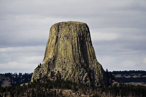
Devil's Tower 2
Picture: Devil's Tower, Wyoming

Class.

You are should be up to around page 170 by this Thursday. In any case, the book should definitely be finished by Tuesday. We will have our final class discussion next Tuesday on the book.

Enjoy.

Denny

New Course for Next Fall (I Will Teach It)

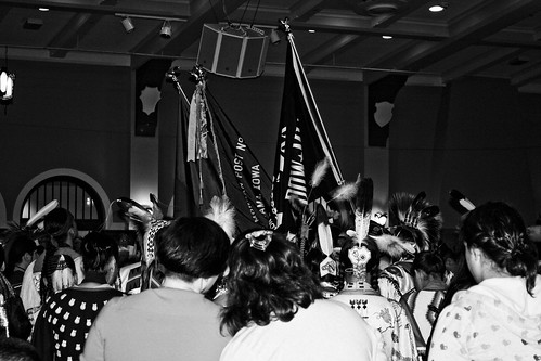
Iowa Powwow Opening
Picture: University of Iowa Powwow, 2009.

History of Homesteading

Homesteading is often described as one of the most significant experiences in the history of westward expansion and European settler-states. This course's objective is to comparatively examine the history of homesteading in the United States, Canada and Australia and its far-reaching effects upon landscape and people. We will think critically about this history by studying secondary sources, historical novels and film. Students will be expected to participate in class discussions, write and present two shorts paper and complete two exams.

Monday, April 27, 2009

Pictures from Pikes Peak in Iowa

Here are a few pictures from Pikes Peaks. It is within 5 minutes of Effigy Mounds so if anyone decides to check that out, this place is very similar and free!!!